
Merrill topographic map
Interactive map
Click on the map to display elevation.
About this map
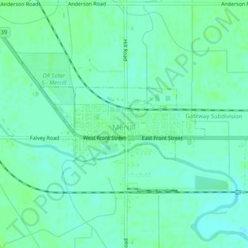
Name: Merrill topographic map, elevation, terrain.
Location: Merrill, Klamath County, Oregon, United States (42.02142 -121.61291 42.02954 -121.58868)
Average elevation: 1,241 m
Minimum elevation: 1,236 m
Maximum elevation: 1,244 m
Merrill is at an elevation of 4,071 feet (1,241 m) in southern Klamath County, near the Oregon–California border. It is along Oregon Route 39 southeast of Klamath Falls and northwest of Tulelake. Lower Klamath Lake and Tule Lake, both in California, are slightly south of Merrill. By highway, the city is 20 miles (32 km) from Klamath Falls and 300 miles (480 km) from Portland.
Other topographic maps
Click on a map to view its topography, its elevation and its terrain.
Klamath Falls
United States > Oregon > Klamath County
Klamath Falls, Klamath County, Oregon, 97601, United States
Average elevation: 1,312 m
Dairy
United States > Oregon > Klamath County
Dairy, Klamath County, Oregon, 97625, United States
Average elevation: 1,300 m
Crater Lake National Park
United States > Oregon > Klamath County
Crater Lake National Park, Klamath County, Oregon, 97604, United States
Average elevation: 1,726 m
Rock Point
United States > Oregon > Klamath County
Rock Point, Klamath County, Oregon, 97731, United States
Average elevation: 1,415 m
Altamont
United States > Oregon > Klamath County
Altamont, Klamath County, Oregon, 97603, United States
Average elevation: 1,310 m
Lake of the Woods
United States > Oregon > Klamath County
Lake of the Woods, Klamath County, Oregon, United States
Average elevation: 1,588 m
Chemult
United States > Oregon > Klamath County
Chemult, Klamath County, Oregon, United States
Average elevation: 1,480 m
Crescent
United States > Oregon > Klamath County
Crescent, Klamath County, Oregon, United States
Average elevation: 1,389 m
Sprague River
United States > Oregon > Klamath County
Sprague River, Klamath County, Oregon, 97639, United States
Average elevation: 1,472 m
Malin
United States > Oregon > Klamath County
Malin, Klamath County, Oregon, United States
Average elevation: 1,241 m
Altamont
United States > Oregon > Klamath County > Altamont
Altamont, Klamath County, Oregon, 97603, United States
Average elevation: 1,285 m
Mount Scott
United States > Oregon > Klamath County
Mount Scott, Klamath County, Oregon, United States
Average elevation: 2,295 m
Fort Klamath
United States > Oregon > Klamath County
Fort Klamath, Klamath County, Oregon, United States
Average elevation: 1,273 m
Chiloquin
United States > Oregon > Klamath County
Chiloquin, Klamath County, Oregon, United States
Average elevation: 1,302 m
Beatty
United States > Oregon > Klamath County
Beatty, Klamath County, Oregon, 97602, United States
Average elevation: 1,330 m
Odell Lake
United States > Oregon > Klamath County > Odell Lake
Odell Lake, Klamath County, Oregon, United States
Average elevation: 1,492 m
Crater Lake
United States > Oregon > Klamath County
Crater Lake, Klamath County, Oregon, United States
Average elevation: 1,971 m
Bonanza
United States > Oregon > Klamath County
Bonanza, Klamath County, Oregon, United States
Average elevation: 1,263 m
Keno
United States > Oregon > Klamath County
Keno, Klamath County, Oregon, 97627, United States
Average elevation: 1,287 m
Mount Mazama
United States > Oregon > Klamath County
Mount Mazama, Klamath County, Oregon, United States
Average elevation: 1,880 m