
Make a donation
Bamyan Province topographic map
Click on the map to display elevation.
Make a donation
About this map
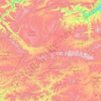
Name: Bamyan Province topographic map, elevation, terrain.
Location: Bamyan Province, Afghanistan (33.91186 66.27695 35.48097 68.26638)
Average elevation: 3,119 m
Minimum elevation: 1,439 m
Maximum elevation: 4,987 m
Make a donation
Other topographic maps
Click on a map to view its topography, its elevation and its terrain.
Kandahar
Afghanistan > Kandahar Province > Kandahar
Kandahar (English: /ˈkændəhɑːr/; Pashto: کندهار, romanized: Kandahār; Dari: قندهار, romanized: Qandahār) is a city in Afghanistan, located in the south of the country on the Arghandab River, at an elevation of 1,010 m (3,310 ft). It is Afghanistan's second largest city after Kabul, with a…
Average elevation: 1,048 m
Ghazni
Ghazni's climate is transitional between a cold semi-arid climate (Köppen climate classification BSk) and a hot-summer humid continental climate (Dsa). It has cold, snowy winters and warm, dry summers. Precipitation is low and mostly falls in winter (as snow) and spring (as rain). Winters are very cold, with…
Average elevation: 2,341 m