
Thank you for supporting this site ❤️
Make a donation
Make a donation
Mellaar topographic map
Click on the map to display elevation.
Thank you for supporting this site ❤️
Make a donation
Make a donation
About this map
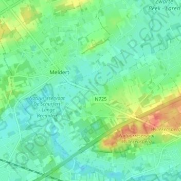
Name: Mellaar topographic map, elevation, terrain.
Location: Mellaar, Lummen, Hasselt, Limburg, Vlaanderen, 3560, België (50.97454 5.13278 51.01454 5.17278)
Average elevation: 30 m
Minimum elevation: 15 m
Maximum elevation: 65 m
Thank you for supporting this site ❤️
Make a donation
Make a donation
Other topographic maps
Click on a map to view its topography, its elevation and its terrain.
Meldert
België > Limburg > Hasselt > Lummen
Meldert ligt in het zuiden van het Kempens laagplateau, maar ten noorden van de plaats ligt een reeks getuigenheuvels die van het noordoosten in zuidwestelijke richting loopt en waarvan de hoogte tot 55 meter oploopt. Meldert ligt in de vallei van de Zwarte Beek, met in het noordoosten het natuurgebied Vallei…
Average elevation: 33 m
Thank you for supporting this site ❤️
Make a donation
Make a donation