Geolocate

伊合昂街道 topographic map

Interactive map

Click on the map to display elevation.

About this map

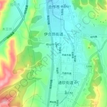
Name: 伊合昂街道 topographic map, elevation, terrain.

Location: 伊合昂街道, 合作市, 甘南藏族自治州, 甘肃省, 中国 (34.97388 102.89478 35.00307 102.90917)

Average elevation: 2,923 m

Minimum elevation: 2,873 m

Maximum elevation: 3,037 m

Other topographic maps

Click on a map to view its topography, its elevation and its terrain.

吉利

中国 > 甘肃省 > 合作市 > 勒秀镇

吉利, 勒秀镇, 合作市, 甘南藏族自治州, 甘肃省, 中国

Average elevation: 3,174 m

甘南州

中国 > 甘肃省 > 合作市

甘南州, 通钦街道 ཐོད་ཆིངས་ཁྲོམ་གཞུང་།, 合作市, 甘南藏族自治州, 甘肃省, 747000, 中国

Average elevation: 3,075 m

合作市

中国 > 甘肃省 > 合作市 > 坚木克尔街道

合作市, 坚木克尔街道, 合作市, 甘南藏族自治州, 甘肃省, 747000, 中国

Average elevation: 3,199 m

当周街道

中国 > 甘肃省 > 合作市

当周街道, 合作市, 甘南藏族自治州, 甘肃省, 中国

Average elevation: 3,054 m