
Colonia Álvaro Obregón topographic map
Interactive map
Click on the map to display elevation.
About this map
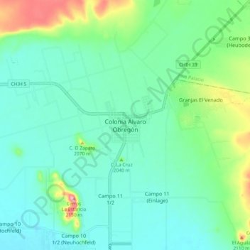
Name: Colonia Álvaro Obregón topographic map, elevation, terrain.
Location: Colonia Álvaro Obregón, Cuauhtémoc, Chihuahua, México (28.70915 -106.94699 28.78915 -106.86699)
Average elevation: 2,038 m
Minimum elevation: 2,002 m
Maximum elevation: 2,151 m
Other topographic maps
Click on a map to view its topography, its elevation and its terrain.
Cuauhtémoc
México > Chihuahua > Cuauhtémoc
Cuauhtémoc, Chihuahua, 31500, México
Average elevation: 2,073 m