
Make a donation
Glencoe topographic map
Click on the map to display elevation.
Make a donation
Glencoe
The village is surrounded on three sides by upper-income communities, with Highland Park on the north, Northbrook on the west, and Winnetka to the south. The Skokie Lagoons are located in the forest preserve to the immediate west of the village. The same forest preserve has a bicycle trail that connects to other forest preserves to the south. In the village, the Green Bay Trail allows bicyclists to travel as far south as Wilmette and north past Lake Forest. The highest point of elevation in Glencoe is 690 feet (210 m) above sea level along Green Bay Road in the northern part of the village.
Make a donation
About this map
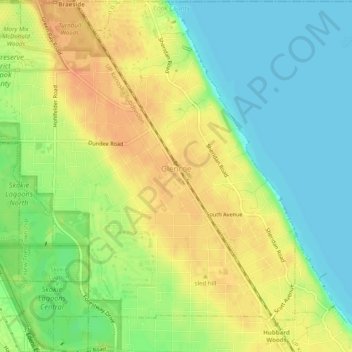
Name: Glencoe topographic map, elevation, terrain.
Average elevation: 194 m
Minimum elevation: 175 m
Maximum elevation: 212 m
Make a donation