
Newland topographic map
Interactive map
Click on the map to display elevation.
About this map
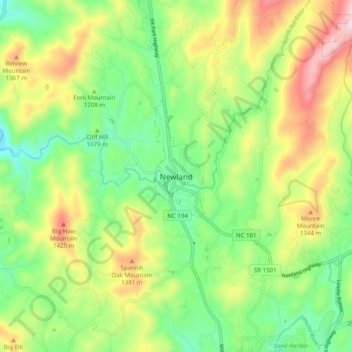
Name: Newland topographic map, elevation, terrain.
Location: Newland, Avery County, North Carolina, 28653, United States (36.04735 -81.96734 36.12735 -81.88734)
Average elevation: 1,199 m
Minimum elevation: 987 m
Maximum elevation: 1,535 m
At an elevation of 3,621 feet or 1,104 metres, it is the highest county seat in the Eastern United States (based on elevations in the USGS database).