
Thank you for supporting this site ❤️
Make a donation
Make a donation
Lac Riopel topographic map
Click on the map to display elevation.
Thank you for supporting this site ❤️
Make a donation
Make a donation
About this map
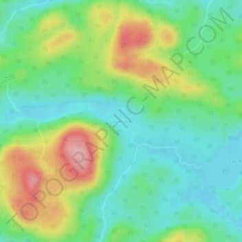
Name: Lac Riopel topographic map, elevation, terrain.
Average elevation: 499 m
Minimum elevation: 451 m
Maximum elevation: 589 m
Thank you for supporting this site ❤️
Make a donation
Make a donation
Other topographic maps
Click on a map to view its topography, its elevation and its terrain.
Thank you for supporting this site ❤️
Make a donation
Make a donation
Thank you for supporting this site ❤️
Make a donation
Make a donation
Thank you for supporting this site ❤️
Make a donation
Make a donation
Rivière Saint-Cyr Sud
Canada > Québec > La Vallée-de-l'Or > Senneterre (ville)
Average elevation: 405 m
Thank you for supporting this site ❤️
Make a donation
Make a donation
Thank you for supporting this site ❤️
Make a donation
Make a donation