
Thank you for supporting this site ❤️
Make a donation
Make a donation
Montner topographic map
Click on the map to display elevation.
Thank you for supporting this site ❤️
Make a donation
Make a donation
About this map
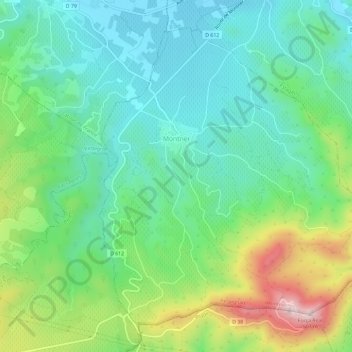
Name: Montner topographic map, elevation, terrain.
Average elevation: 204 m
Minimum elevation: 82 m
Maximum elevation: 492 m
Thank you for supporting this site ❤️
Make a donation
Make a donation
Other topographic maps
Click on a map to view its topography, its elevation and its terrain.
Thank you for supporting this site ❤️
Make a donation
Make a donation
L'Ermitage
France > Occitania > Pyrénées-Orientales > Font-Romeu-Odeillo-Via > L'Ermitage
Average elevation: 1,785 m
Thank you for supporting this site ❤️
Make a donation
Make a donation
Les Escaldes
France > Occitania > Pyrénées-Orientales > Angoustrine-Villeneuve-des-Escaldes
Average elevation: 1,491 m
Thank you for supporting this site ❤️
Make a donation
Make a donation