
County Clare topographic map
Interactive map
Click on the map to display elevation.
About this map
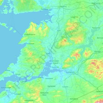
Name: County Clare topographic map, elevation, terrain.
Location: County Clare, Munster, Ireland (52.55447 -9.93876 53.16891 -8.28242)
Average elevation: 67 m
Minimum elevation: -4 m
Maximum elevation: 862 m
Other topographic maps
Click on a map to view its topography, its elevation and its terrain.
Killaloe
Ireland > County Clare > Killaloe
Killaloe, County Clare, Munster, V94 A2W7, Ireland
Average elevation: 58 m