
Warm Springs topographic map
Interactive map
Click on the map to display elevation.
About this map
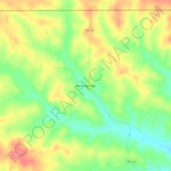
Name: Warm Springs topographic map, elevation, terrain.
Average elevation: 148 m
Minimum elevation: 106 m
Maximum elevation: 191 m
Other topographic maps
Click on a map to view its topography, its elevation and its terrain.
Sand Hill
United States > Arkansas > Randolph County > Pocahontas
Sand Hill, Pocahontas, Randolph County, Arkansas, 72455, United States
Average elevation: 118 m
Maynard
United States > Arkansas > Randolph County
Maynard, Randolph County, Arkansas, 72444, United States
Average elevation: 128 m
O'Kean
United States > Arkansas > Randolph County
O'Kean, Randolph County, Arkansas, 72425, United States
Average elevation: 82 m
Pocahontas
United States > Arkansas > Randolph County > Pocahontas
Pocahontas, Randolph County, Arkansas, United States
Average elevation: 96 m
Pocahontas
United States > Arkansas > Randolph County > Pocahontas
Pocahontas, Randolph County, Arkansas, 72455, United States
Average elevation: 94 m
O"Kean
United States > Arkansas > Randolph County > O"Kean
O"Kean, Randolph County, Arkansas, 72425, United States
Average elevation: 82 m