
Thank you for supporting this site ❤️
Make a donation
Make a donation
Lac Long topographic map
Click on the map to display elevation.
Thank you for supporting this site ❤️
Make a donation
Make a donation
About this map
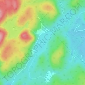
Name: Lac Long topographic map, elevation, terrain.
Location: Lac Long, Mandeville, D'Autray, Lanaudière, Québec, Canada (46.41544 -73.27788 46.42363 -73.26884)
Average elevation: 251 m
Minimum elevation: 197 m
Maximum elevation: 355 m
Thank you for supporting this site ❤️
Make a donation
Make a donation
Other topographic maps
Click on a map to view its topography, its elevation and its terrain.
Rivière Mandeville
Canada > Québec > D'Autray > Mandeville > Saint-Charles-de-Mandeville
Average elevation: 229 m