
Moosup topographic map
Interactive map
Click on the map to display elevation.
About this map
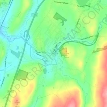
Name: Moosup topographic map, elevation, terrain.
Average elevation: 95 m
Minimum elevation: 50 m
Maximum elevation: 169 m
Other topographic maps
Click on a map to view its topography, its elevation and its terrain.
Plainfield Village
United States > Connecticut > Northeastern Connecticut Planning Region > Plainfield
Plainfield Village, Plainfield, Northeastern Connecticut Planning Region, Connecticut, 06374, United States
Average elevation: 62 m
Wauregan
United States > Connecticut > Northeastern Connecticut Planning Region > Plainfield
Wauregan, Plainfield, Northeastern Connecticut Planning Region, Connecticut, 06387, United States
Average elevation: 68 m