
Make a donation
Oed topographic map
Click on the map to display elevation.
Make a donation
About this map
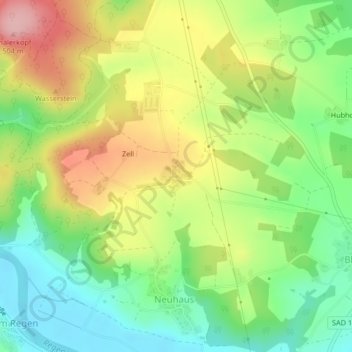
Name: Oed topographic map, elevation, terrain.
Average elevation: 411 m
Minimum elevation: 341 m
Maximum elevation: 504 m
Make a donation
Other topographic maps
Click on a map to view its topography, its elevation and its terrain.
Obermainsbach
Deutschland > Bayern > Landkreis Schwandorf > Nittenau > Bleich
Average elevation: 385 m
Make a donation
Stefling
Deutschland > Bayern > Landkreis Schwandorf > Nittenau
Annahaid | Asang | Auhof | Bachbügl | Bergham | Berghof | Berglarn | Bleich | Bodenstein | Brunn | Diepenried | Dobl | Dürrmaul | Eckartsreuth | Eichlgütl | Elendhof | Entermainsbach | Eschlbach | Fichtenhof | Fischbach | Forsting | Geiseck | Goppeltshof | Gunt | Hadriwa (Nittenau) | Haiderhöf |…
Average elevation: 429 m
Vorderkohlstetten
Deutschland > Bayern > Landkreis Schwandorf > Nittenau > Hof am Regen
Average elevation: 429 m
Hof am Regen
Deutschland > Bayern > Landkreis Schwandorf > Nittenau > Hof am Regen
Average elevation: 418 m
Make a donation