Geolocate

Le Ruffa topographic map

Interactive map

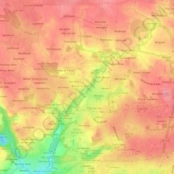
Click on the map to display elevation.

About this map

Name: Le Ruffa topographic map, elevation, terrain.

Location: Le Ruffa, Bohars, Brest, Finistère, Bretagne, France métropolitaine, 29820, France (48.41005 -4.52599 48.45005 -4.48599)

Average elevation: 69 m

Minimum elevation: -6 m

Maximum elevation: 98 m

Other topographic maps

Click on a map to view its topography, its elevation and its terrain.

Kerglos

France > Bretagne > Finistère > Bohars

Kerglos, Bohars, Brest, Finistère, Bretagne, France métropolitaine, 29820, France

Average elevation: 71 m

Lez Huel

France > Bretagne > Finistère > Bohars

Lez Huel, Bohars, Brest, Finistère, Bretagne, France métropolitaine, 29820, France

Average elevation: 70 m

Pont Aliben

France > Bretagne > Finistère > Bohars

Pont Aliben, Bohars, Brest, Finistère, Bretagne, France métropolitaine, 29820, France

Average elevation: 51 m

Le Lannoc

France > Bretagne > Finistère > Bohars > Le Lannoc

Le Lannoc, Bohars, Brest, Finistère, Bretagne, France métropolitaine, 29820, France

Average elevation: 50 m

Kermaria

France > Bretagne > Finistère > Bohars > Kermaria

Kermaria, Bohars, Brest, Finistère, Bretagne, France métropolitaine, 29820, France

Average elevation: 69 m