
Make a donation
Jefferson topographic map
Click on the map to display elevation.
Make a donation
Jefferson
Jefferson is located on U.S. Route 2 between Lancaster and Randolph, west of the midpoint between the Vermont and Maine borders. Set astride the broad Israel River valley, the town commands remarkable views of the Presidential Range and other White Mountain summits. Mount Starr King, with an elevation of 3,907 feet (1,191 m) and named for Thomas Starr King, is the highest point in town, near the town's northern border. It is regularly traversed by hikers scaling nearby 4,006-foot (1,221 m) Mount Waumbek, one of the "four-thousand footers"—the 48 peaks above 4,000 feet (1,200 m) in New Hampshire. Jefferson lies fully within the Connecticut River watershed.
Make a donation
About this map
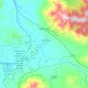
Name: Jefferson topographic map, elevation, terrain.
Location: Jefferson, Coös County, New Hampshire, 03583, United States (44.33323 -71.54324 44.46090 -71.38018)
Average elevation: 493 m
Minimum elevation: 294 m
Maximum elevation: 1,208 m
Make a donation
Other topographic maps
Click on a map to view its topography, its elevation and its terrain.
Mount Washington
United States > New Hampshire > Coos County
Mount Washington, in New Hampshire, is the highest peak in the Northeastern United States at 6,288.2 ft (1,916.6 m) and the most topographically prominent mountain east of the Mississippi River.
Average elevation: 1,568 m
Mount Washington
United States > New Hampshire > Coos County
Mount Washington, also known as Agiocochook, is an ultra-prominent mountain in the state of New Hampshire. It is the highest peak in the Northeastern United States at 6,288.2 ft (1,916.6 m) and the most topographically prominent mountain east of the Mississippi River.
Average elevation: 1,568 m
Mount Adams
United States > New Hampshire > Coos County
Mount Adams, elevation 5,793 feet (1,766 m) above sea level, is a mountain in New Hampshire, the second highest peak in the Northeast United States after its nearby neighbor, Mount Washington. Located in the northern Presidential Range, Mount Adams was named after John Adams, the second President of the United…
Average elevation: 1,379 m
Make a donation
Mount Washington
United States > New Hampshire > Coos County
Mount Washington is an ultra-prominent mountain in the state of New Hampshire. It is the highest peak in the Northeastern United States at 6,288.2 ft (1,916.6 m) and the most topographically prominent mountain east of the Mississippi River.
Average elevation: 1,568 m
Make a donation
Make a donation
Mount Washington
United States > New Hampshire > Coos County
Mount Washington, also known as Agiocochook, is an ultra-prominent mountain in the state of New Hampshire. It is the highest peak in the Northeastern United States at 6,288.2 ft (1,916.6 m) and the most topographically prominent mountain east of the Mississippi River.
Average elevation: 1,568 m
Make a donation
Make a donation