
Thank you for supporting this site ❤️
Make a donation
Make a donation
Coonarr topographic map
Click on the map to display elevation.
Thank you for supporting this site ❤️
Make a donation
Make a donation
About this map
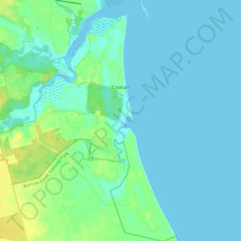
Name: Coonarr topographic map, elevation, terrain.
Location: Coonarr, Bundaberg Region, Queensland, Australia (-25.01071 152.43641 -24.92532 152.50567)
Average elevation: 5 m
Minimum elevation: -2 m
Maximum elevation: 21 m
Thank you for supporting this site ❤️
Make a donation
Make a donation
Other topographic maps
Click on a map to view its topography, its elevation and its terrain.
Isis River
Australia > Queensland > Bundaberg Region > South Isis > Isis River
Average elevation: 43 m
Thank you for supporting this site ❤️
Make a donation
Make a donation
Thank you for supporting this site ❤️
Make a donation
Make a donation