
Thank you for supporting this site ❤️
Make a donation
Make a donation
Chamdo City topographic map
Click on the map to display elevation.
Thank you for supporting this site ❤️
Make a donation
Make a donation
About this map
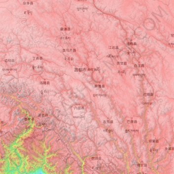
Name: Chamdo City topographic map, elevation, terrain.
Location: Chamdo City, Tibet, 854200, China (28.43845 93.59751 32.58948 99.11555)
Average elevation: 4,151 m
Minimum elevation: 203 m
Maximum elevation: 7,078 m
Thank you for supporting this site ❤️
Make a donation
Make a donation
Other topographic maps
Click on a map to view its topography, its elevation and its terrain.
Mount Everest
China > Tibet > Tingri County
Mount Everest (Nepali: सगरमाथा, romanized: Sagarmāthā; Tibetan: Chomolungma ཇོ་མོ་གླང་མ; Chinese: 珠穆朗玛峰; pinyin: Zhūmùlǎngmǎ Fēng) is Earth's highest mountain above sea level, located in the Mahalangur Himal sub-range of the Himalayas. The China–Nepal…
Average elevation: 7,851 m