
Bartın Merkez topographic map
Interactive map
Click on the map to display elevation.
About this map
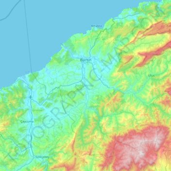
Name: Bartın Merkez topographic map, elevation, terrain.
Location: Bartın Merkez, Bartın, Black Sea Region, Turkey (41.30294 32.09511 41.78936 32.86782)
Average elevation: 324 m
Minimum elevation: 0 m
Maximum elevation: 1,746 m
Other topographic maps
Click on a map to view its topography, its elevation and its terrain.
Yeniköy
Turkey > Bartın Merkez > Arıt > Yeniköy
Yeniköy, Arıt, Bartın Merkez, Bartın, Black Sea Region, Turkey
Average elevation: 691 m