
The Grove topographic map
Interactive map
Click on the map to display elevation.
About this map
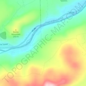
Name: The Grove topographic map, elevation, terrain.
Average elevation: 240 m
Minimum elevation: 147 m
Maximum elevation: 382 m
Other topographic maps
Click on a map to view its topography, its elevation and its terrain.
Green Street
United States > New York > Essex County > Town of Jay
Green Street, Town of Jay, Essex County, New York, United States
Average elevation: 320 m
North Jay
United States > New York > Essex County > Town of Jay
North Jay, Town of Jay, Essex County, New York, United States
Average elevation: 263 m
Rome
United States > New York > Essex County > Town of Jay
Rome, Town of Jay, Essex County, New York, 12912, United States
Average elevation: 237 m
Upper Jay
United States > New York > Essex County > Town of Jay
Upper Jay, Town of Jay, Essex County, New York, 12987, United States
Average elevation: 323 m