Geolocate

Lagos topographic map

Click on the map to display elevation.

About this map

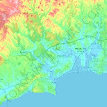
Name: Lagos topographic map, elevation, terrain.

Location: Lagos, Faro, Portugal (37.07122 -8.85321 37.23502 -8.61916)

Average elevation: 57 m

Minimum elevation: -2 m

Maximum elevation: 255 m

Other topographic maps

Click on a map to view its topography, its elevation and its terrain.

Lagos

Portugal > Faro

Average elevation: 42 m

Hortas do Tabual

Portugal > Faro > Vila do Bispo

Average elevation: 58 m

Vale Telheiro

Portugal > Faro > Loulé

Average elevation: 217 m

Algarve

Portugal > Faro > Loulé

The Algarve is located in the southernmost area of continental Portugal and the southwesternmost area of the Iberian Peninsula and mainland Europe, covering an area of 4,997 km2 (1,929 sq mi). It borders to the north with the Alentejo region (Alentejo Litoral and Baixo Alentejo), to the south and west with the…

Average elevation: 72 m

Alcoutim

Portugal > Faro > Alcoutim e Pereiro

Average elevation: 92 m

Alfambras

Portugal > Faro > Aljezur

Average elevation: 119 m

Montes Juntos

Portugal > Faro > Albufeira > Guia

Average elevation: 29 m

Venda

Portugal > Faro > São Bartolomeu de Messines

Average elevation: 87 m

Monte Judeu

Portugal > Faro > Portimão

Average elevation: 40 m

Jogo

Portugal > Faro > Monchique

Average elevation: 204 m

Jardim Vale Faro

Portugal > Faro > Albufeira

Average elevation: 32 m

Venda

Portugal > Faro > São Bartolomeu de Messines

Average elevation: 87 m

Venda

Portugal > Faro > São Bartolomeu de Messines

Average elevation: 87 m

Pedreira de Santo Estêvão

Portugal > Faro > Silves

Average elevation: 75 m

Praia do Carvalho

Portugal > Faro > Lagoa

Average elevation: 25 m

Corotelo

Portugal > Faro > São Brás de Alportel

Average elevation: 269 m

Praia Verde

Portugal > Faro > Castro Marim

Average elevation: 7 m

Algarve

Portugal > Faro > Loulé

The Algarve is located in the southernmost area of continental Portugal and the southwesternmost area of the Iberian Peninsula and mainland Europe, covering an area of 4,997 km2 (1,929 sq mi). It borders to the north with the Alentejo region (Alentejo Litoral and Baixo Alentejo), to the south and west with the…

Average elevation: 72 m

Moncarapacho

Portugal > Faro > Olhão

Average elevation: 75 m

Foia

Portugal > Faro > Monchique

Average elevation: 724 m

Farrobo

Portugal > Faro > São Brás de Alportel

Average elevation: 280 m

Benagil Cave

Portugal > Faro > Lagoa

Average elevation: 24 m

Rua da Ria

Portugal > Faro > Lagos > Odiáxere

Average elevation: 1 m

Beco

Portugal > Faro > Vila Nova de Cacela

Average elevation: 50 m

Lagoa

Portugal > Faro

Average elevation: 53 m

São Pedro

Portugal > Faro > Tavira > Santa Luzia

Average elevation: 21 m

Murtais

Portugal > Faro > Olhão

Average elevation: 34 m

Gralheira

Portugal > Faro > São Bartolomeu de Messines

Average elevation: 155 m

Alcoutim

Portugal > Faro > Alcoutim e Pereiro

Average elevation: 92 m

Carrapateira

Portugal > Faro > São Marcos da Serra

Average elevation: 208 m

Foral

Portugal > Faro > Algoz e Tunes

Average elevation: 93 m

Barbelote

Portugal > Faro > Monchique

Average elevation: 594 m

Querença

Portugal > Faro > Querença, Tôr e Benafim > Querença

Average elevation: 228 m

Silves Gare

Portugal > Faro > Silves > Silves Gare

Average elevation: 49 m

Quinta do Lago

Portugal > Faro > Almancil > Quinta do Lago

Average elevation: 31 m

Sapeira

Portugal > Faro > São Marcos da Serra > Sapeira

Average elevation: 159 m

Montenegro

Portugal > Faro > Montenegro > Montenegro

Average elevation: 10 m

Mexilhoeira Grande

Portugal > Faro > Portimão

Average elevation: 28 m

Tavira

Portugal > Faro > Tavira

Average elevation: 88 m

Carvoeiro

Portugal > Faro > Lagoa e Carvoeiro > Carvoeiro

Average elevation: 24 m

Marmelete

Portugal > Faro > Marmelete > Marmelete

Average elevation: 359 m

Caramujeira

Portugal > Faro > Lagoa

Average elevation: 43 m

Estômbar

Portugal > Faro > Estômbar e Parchal

Average elevation: 34 m