
Thank you for supporting this site ❤️
Make a donation
Make a donation
Wulveringem topographic map
Click on the map to display elevation.
Thank you for supporting this site ❤️
Make a donation
Make a donation
Wulveringem
Wulveringem ligt op de grens van Zandlemig Vlaanderen en, in het noorden, de Oudlandpolders. De hoogte bedraagt ongeveer 10 meter.
Thank you for supporting this site ❤️
Make a donation
Make a donation
About this map
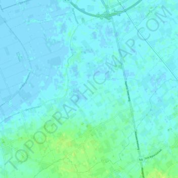
Name: Wulveringem topographic map, elevation, terrain.
Location: Wulveringem, Beauvoorde, Veurne, West-Vlaanderen, 8630, België (51.01380 2.61506 51.04665 2.71592)
Average elevation: 3 m
Minimum elevation: -4 m
Maximum elevation: 12 m
Thank you for supporting this site ❤️
Make a donation
Make a donation
Other topographic maps
Click on a map to view its topography, its elevation and its terrain.
Westhoekduinen, duinen van Cabour, De Moeren en plateau van Izenberge
België > West-Vlaanderen > Veurne > Veurne
Average elevation: 1 m
Thank you for supporting this site ❤️
Make a donation
Make a donation