Geolocate

Macdonnell Region topographic map

Interactive map

Click on the map to display elevation.

About this map

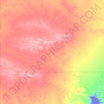
Name: Macdonnell Region topographic map, elevation, terrain.

Location: Macdonnell Region, Northern Territory, 0872, Australia (-25.99862 129.00054 -22.85395 137.99905)

Average elevation: 390 m

Minimum elevation: -16 m

Maximum elevation: 1,253 m

Other topographic maps

Click on a map to view its topography, its elevation and its terrain.

Inner West

Australia > New South Wales > Sydney

Average elevation: 19 m

Sydney

Australia > New South Wales

Phillip had been given no instructions for urban development, but in July 1788 submitted a plan for the new town at Sydney Cove. It included a wide central avenue, a permanent Government House, law courts, hospital and other public buildings, but no provision for warehouses, shops, or other commercial…

Average elevation: 53 m

North Sydney

Australia > New South Wales > Sydney

Average elevation: 50 m

Rocksberg

Australia > Queensland

The Caboolture River flows from north to east through the locality with Zillmans Crossing (27°07′18″S 152°51′32″E / 27.1218°S 152.8588°E / -27.1218; 152.8588 (Zillmans Crossing)) being a former ford (now a low-level bridge) across the river. The ford was part of the Old North Road (now…

Average elevation: 151 m

Byron Bay

Australia > New South Wales

Average elevation: 7 m

Leeman

Australia > Western Australia

Average elevation: 5 m

Perth

Australia > Western Australia > City of Perth

Average elevation: 26 m

Greater Brisbane

Australia > Queensland

Average elevation: 87 m

Booval

Australia > Queensland

Average elevation: 30 m

Western Australia

Australia

Because the only mountain-building since then has been of the Stirling Range with the rifting from Antarctica, the land is extremely eroded and ancient, with no part of the state above 1,249 metres (4,098 ft) AHD (at Mount Meharry in the Hamersley Range of the Pilbara region). Most of the state is a low…

Average elevation: 194 m

New South Wales

Australia

The climate in the southern half of the state is generally warm to hot in summer and cool in the winter. The seasons are more defined in the southern half of the state, especially as one moves inland towards South West Slopes, Central West and the Riverina region. The climate in the northeast region of the…

Average elevation: 154 m

Tasmania

Australia

The most mountainous region is the Central Highlands area, which covers most of the central western parts of the state. The Midlands located in the central east, is fairly flat, and is predominantly used for agriculture, although farming activity is scattered throughout the state. Tasmania's tallest mountain…

Average elevation: 6 m

Epping

Australia > New South Wales > Sydney

Average elevation: 96 m

Carrabolla

Australia > New South Wales

Average elevation: 617 m

Nowendoc

Australia > New South Wales

Average elevation: 869 m

Ansons Bay

Australia > Tasmania

Average elevation: 45 m

Camden

Australia > New South Wales > Sydney

Average elevation: 71 m

Minnamurra

Australia > New South Wales

Average elevation: 5 m

Donvale

Australia > Victoria > Melbourne

Average elevation: 108 m

Templestowe Lower

Australia > Victoria > Melbourne

Average elevation: 55 m

Lake Eppalock

Australia > Victoria

Average elevation: 219 m

Kalbarri

Australia > Western Australia

Kalbarri is a coastal town in the Mid West region located 592 km (368 mi) north of Perth, Western Australia. The town is located at the mouth of the Murchison River which has an elevation of 6 metres (20 ft). It is connected by public transport to Perth via Transwa coach services N1 and N2.

Average elevation: 57 m

Purnululu

Australia > Western Australia

Average elevation: 277 m

Port Campbell

Australia > Victoria

Average elevation: 46 m

Lake Eildon

Australia > Victoria

Average elevation: 386 m

Nambung

Australia > Western Australia

Average elevation: 60 m

Karijini

Australia > Western Australia

Average elevation: 688 m

Lake Argyle

Australia > Western Australia

Average elevation: 174 m

Shire Of Exmouth

Australia > Western Australia

Average elevation: 24 m

Dove Lake

Australia > Tasmania > Cradle Mountain

Average elevation: 1,060 m

Metung

Australia > Victoria

Average elevation: 9 m

Stockport

Australia > South Australia

Average elevation: 176 m

Buderim

Australia > Queensland > Sunshine Coast

Average elevation: 39 m

Adelaide

Australia > South Australia > Adelaide City Council

Based on the ideas of Edward Gibbon Wakefield about colonial reform, Robert Gouger petitioned the British government to create a new colony in Australia, resulting in the passage of the South Australia Act 1834. Physical establishment of the colony began with the arrival of the first British colonisers in…

Average elevation: 146 m

Echuca

Australia > Victoria

Average elevation: 100 m

Lane Cove

Australia > New South Wales > Sydney

Average elevation: 55 m

Melbourne Water Reserve

Australia > Victoria > Melbourne

Average elevation: 127 m

Bowral

Australia > New South Wales

Average elevation: 690 m

Alice Springs

Australia > Town of Alice Springs

Temperatures in Alice Springs vary widely, and rainfall can vary quite dramatically from year to year. In summer, the average maximum temperature is in the mid-30s, whereas in winter the average minimum temperature can be 5.5 °C (41.9 °F), with an average of 12.4 nights below freezing every year, providing…

Average elevation: 584 m

Melbourne

Australia > Victoria

Melbourne is also prone to isolated convective showers forming when a cold pool crosses the state, especially if there is considerable daytime heating. These showers are often heavy and can include hail, squalls, and significant drops in temperature, but they often pass through very quickly with a rapid…

Average elevation: 185 m

Sunshine Coast

Australia > Queensland > Maroochydore

Average elevation: 7 m

South Australia

Australia > South Australia

Average elevation: 110 m

Tanami East

Australia > Barkly Region

Average elevation: 264 m

Maleny

Australia > Queensland > Maleny

Average elevation: 364 m