
Thank you for supporting this site ❤️
Make a donation
Make a donation
Anderson County topographic map
Click on the map to display elevation.
Thank you for supporting this site ❤️
Make a donation
Make a donation
About this map
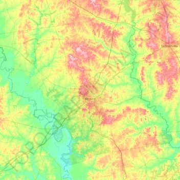
Name: Anderson County topographic map, elevation, terrain.
Location: Anderson County, Texas, United States (31.50368 -96.06480 32.08448 -95.25888)
Average elevation: 117 m
Minimum elevation: 53 m
Maximum elevation: 233 m
Thank you for supporting this site ❤️
Make a donation
Make a donation
Other topographic maps
Click on a map to view its topography, its elevation and its terrain.