
Make a donation
Rothley topographic map
Click on the map to display elevation.
Make a donation
About this map
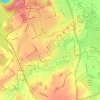
Name: Rothley topographic map, elevation, terrain.
Location: Rothley, Charnwood, Leicestershire, England, United Kingdom (52.69276 -1.17440 52.72932 -1.11832)
Average elevation: 64 m
Minimum elevation: -22 m
Maximum elevation: 102 m
Make a donation
Other topographic maps
Click on a map to view its topography, its elevation and its terrain.
Bradgate Park
United Kingdom > England > Leicestershire > Charnwood > Newtown Linford
Overlying the Beacon Hill Formation, but found a little further down the hillside to the south, are the Bradgate Formation beds, the most notable of which is the Sliding Stone Slump Breccia rocks. Forming a line of crags below Old John, these are laminated mudstones, with layers of sandstone, mainly of…
Average elevation: 126 m
Watermead Country Park
United Kingdom > England > Leicestershire > Charnwood > Birstall
Average elevation: 59 m
Make a donation
Moat Hill Spinney
United Kingdom > England > Leicestershire > Charnwood > Cotes
Average elevation: 50 m
Make a donation
Lea Wood
United Kingdom > England > Leicestershire > Charnwood > Newtown Linford
Average elevation: 170 m
Make a donation
Old John
United Kingdom > England > Leicestershire > Charnwood > Newtown Linford
Average elevation: 143 m
Six Hills
United Kingdom > England > Leicestershire > Charnwood > Burton on the Wolds
Average elevation: 128 m
Make a donation
Swithland Wood
United Kingdom > England > Leicestershire > Charnwood > Swithland
Average elevation: 107 m
Beacon Hill Country Park
United Kingdom > England > Leicestershire > Charnwood > Woodhouse Eaves
Average elevation: 164 m
Make a donation
Top Town Plantation
United Kingdom > England > Leicestershire > Charnwood > Walton on the Wolds
Average elevation: 85 m
Make a donation