
Make a donation
Hai River topographic map
Click on the map to display elevation.
Make a donation
About this map
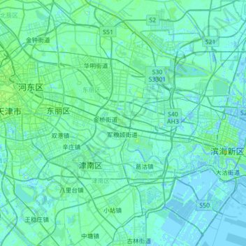
Name: Hai River topographic map, elevation, terrain.
Location: Hai River, Tianjin, China (38.92063 117.17087 39.16065 117.87619)
Average elevation: 2 m
Minimum elevation: -5 m
Maximum elevation: 20 m
Make a donation
Other topographic maps
Click on a map to view its topography, its elevation and its terrain.
Tianjin
Tianjin is located along the west coast of the Bohai Gulf, looking out to the provinces Shandong and Liaoning across those waters, bordered by Beijing 120 kilometers (75 mi) to the northwest, and is surrounded on all sides by Hebei, with the exception of its eastern border, the Bohai Sea. With a latitude…
Average elevation: 5 m
Make a donation
Make a donation
Nankai
China > Tianjin > Nankai District
Nankai District is located in the south-west corner of the urban Tianjin, bordered by Hongqiao District to the north, Hebei and Heping Districts to the north-east, Hexi District to the east and Xiqing District to the south-west. It occupies an area of 40.64 square kilometres (15.69 sq mi). The natural…
Average elevation: 5 m
Make a donation
Make a donation
Make a donation