
Dry Ridge topographic map
Interactive map
Click on the map to display elevation.
About this map
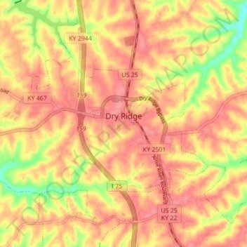
Name: Dry Ridge topographic map, elevation, terrain.
Location: Dry Ridge, Grant County, Kentucky, United States (38.65835 -84.63538 38.70221 -84.56666)
Average elevation: 274 m
Minimum elevation: 222 m
Maximum elevation: 298 m
Other topographic maps
Click on a map to view its topography, its elevation and its terrain.
Crittenden
United States > Kentucky > Grant County > Crittenden
Crittenden, Grant County, Kentucky, 41030, United States
Average elevation: 262 m
Williamstown
United States > Kentucky > Grant County
Williamstown, Grant County, Kentucky, 41097, United States
Average elevation: 262 m