
Lamar topographic map
Interactive map
Click on the map to display elevation.
About this map
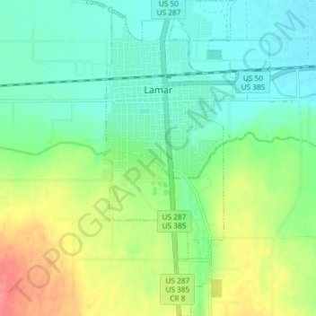
Name: Lamar topographic map, elevation, terrain.
Location: Lamar, Prowers County, Colorado, 81052, United States (38.04596 -102.63348 38.10359 -102.60006)
Average elevation: 1,118 m
Minimum elevation: 1,097 m
Maximum elevation: 1,159 m
Other topographic maps
Click on a map to view its topography, its elevation and its terrain.
Holly
United States > Colorado > Prowers County
Holly, Prowers County, Colorado, United States
Average elevation: 1,037 m