
Hiraan River topographic map
Interactive map
Click on the map to display elevation.
About this map
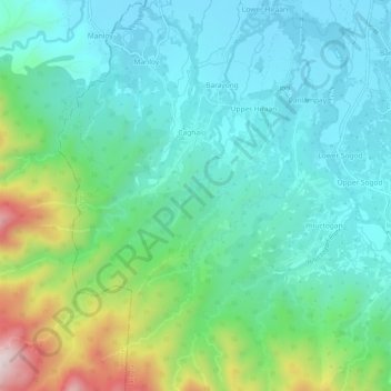
Name: Hiraan River topographic map, elevation, terrain.
Average elevation: 156 m
Minimum elevation: 4 m
Maximum elevation: 622 m
Other topographic maps
Click on a map to view its topography, its elevation and its terrain.
Cogon
Philippines > Leyte > Carigara
Cogon, Carigara, Leyte 2nd District, Leyte, Eastern Visayas, 6529, Philippines
Average elevation: 45 m
Ponong
Philippines > Leyte > Carigara
Ponong, Carigara, Leyte 2nd District, Leyte, Eastern Visayas, 6529, Philippines
Average elevation: 3 m