
Make a donation
Verrine topographic map
Click on the map to display elevation.
Make a donation
About this map
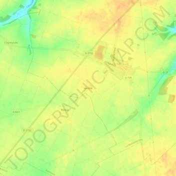
Name: Verrine topographic map, elevation, terrain.
Average elevation: 131 m
Minimum elevation: 110 m
Maximum elevation: 140 m
Make a donation
Other topographic maps
Click on a map to view its topography, its elevation and its terrain.
Orveau-Bellesauve
France > Centre-Val de Loire > Loiret > Le Malesherbois
La ZNIEFF, de deuxième génération et de type 2, dénommée « Coteaux de l'Essonne et de la Rimarde », d'une superficie de 1 812 hectares, s'étend sur 17 communes, dont Orveau-Bellesauve. Son altitude varie entre 90 et 140 m. Les coteaux de l'Essonne et de la Rimarde sont un des espaces les plus…
Average elevation: 127 m
Malesherbes
France > Centre-Val de Loire > Loiret > Le Malesherbois
La superficie de la commune est de 1 761 hectares ; son altitude varie entre 67 et 140 mètres.
Average elevation: 110 m
Nangeville
France > Centre-Val de Loire > Loiret > Le Malesherbois
La ZNIEFF, de deuxième génération et de type 2, dénommée « Coteaux de l'Essonne et de la Rimarde », d'une superficie de 1 812 hectares, s'étend sur 17 communes, dont Nangeville. Son altitude varie entre 90 et 140 m. Les coteaux de l'Essonne et de la Rimarde sont un des espaces les plus intéressants du…
Average elevation: 132 m
Make a donation