
Binche topographic map
Interactive map
Click on the map to display elevation.
About this map
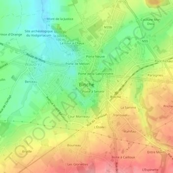
Name: Binche topographic map, elevation, terrain.
Location: Binche, La Louvière, Henegouwen, Wallonië, België (50.39529 4.15698 50.42461 4.20121)
Average elevation: 102 m
Minimum elevation: 58 m
Maximum elevation: 150 m
Other topographic maps
Click on a map to view its topography, its elevation and its terrain.
Houdeng-Gœgnies
België > Henegouwen > La Louvière
Houdeng-Gœgnies, La Louvière, Henegouwen, Wallonië, 7100, België
Average elevation: 117 m
Couture au-dessus de l'Église
België > Henegouwen > La Louvière > Ressaix
Couture au-dessus de l'Église, Ressaix, Binche, La Louvière, Henegouwen, Wallonië, 7134, België
Average elevation: 103 m
Château du Fonteni
België > Henegouwen > La Louvière > Péronnes-lez-Binche
Château du Fonteni, Péronnes-lez-Binche, Binche, La Louvière, Henegouwen, Wallonië, 7130, België
Average elevation: 72 m
Vent de Bise
België > Henegouwen > La Louvière > Houdeng-Aimeries
Vent de Bise, Houdeng-Aimeries, La Louvière, Henegouwen, Wallonië, 7100, België
Average elevation: 105 m
Morlanwelz
België > Henegouwen > La Louvière > Morlanwelz
Morlanwelz, La Louvière, Henegouwen, Wallonië, 7141, België
Average elevation: 143 m
Bray
België > Henegouwen > La Louvière > Binche > Bray
Bray, Binche, La Louvière, Henegouwen, Wallonië, België
Average elevation: 73 m
Carnières
België > Henegouwen > La Louvière > Carnières
Carnières, Morlanwelz, La Louvière, Henegouwen, Wallonië, 7141, België
Average elevation: 141 m
Binche
België > Henegouwen > La Louvière
Binche, La Louvière, Henegouwen, Wallonië, België
Average elevation: 127 m
La Louvière
België > Henegouwen > La Louvière
La Louvière, Henegouwen, Wallonië, 7100, België
Average elevation: 113 m