
Sherwood topographic map
Interactive map
Click on the map to display elevation.
About this map
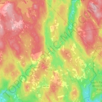
Name: Sherwood topographic map, elevation, terrain.
Average elevation: 182 m
Minimum elevation: 84 m
Maximum elevation: 264 m
Other topographic maps
Click on a map to view its topography, its elevation and its terrain.
Oak Island
Canada > Nouvelle-Écosse > Lunenburg County > Western Shore
Oak Island, Western Shore, Chester District Municipality, Lunenburg County, Nouvelle-Écosse, B0J 3M0, Canada
Average elevation: 2 m
Hubbards
Canada > Nouvelle-Écosse > Lunenburg County > Hubbards
Hubbards, Chester District Municipality, Lunenburg County, Nouvelle-Écosse, B0J 1T0, Canada
Average elevation: 57 m