
Make a donation
Meghalaya topographic map
Click on the map to display elevation.
Make a donation
Meghalaya
Meghalaya, alongside neighbouring Indian states, has been of archaeological interest. People have lived in Meghalaya since the Neolithic period. Neolithic sites discovered so far are located in areas of high elevation in Khasi Hills, Garo Hills and in neighbouring states, where Neolithic style jhum or shifting cultivation is practiced even today. The highland plateaus fed by abundant rains provided safety from floods and a rich soil. The importance of Meghalaya is its possible role in human history via domestication of rice. One of the competing theories for the origin of rice comes from Ian Glover, who states, "India is the center of greatest diversity of domesticated rice with over 20,000 identified species and Northeast India is the most favorable single area of the origin of domesticated rice." The limited archaeology done in the hills of Meghalaya suggest human settlement since ancient times.
Make a donation
About this map
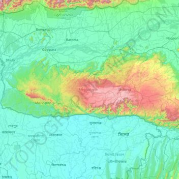
Name: Meghalaya topographic map, elevation, terrain.
Location: Meghalaya, India (25.03065 89.81444 26.11817 92.80274)
Average elevation: 244 m
Minimum elevation: 0 m
Maximum elevation: 2,336 m
Make a donation
Other topographic maps
Click on a map to view its topography, its elevation and its terrain.
Navi Mumbai
India > Maharashtra > Thane > Navi Mumbai
Navi Mumbai (Marathi pronunciation: , also known by its former name New Bombay), is a planned city off the west coast of the Indian state of Maharashtra in Konkan division. The city is divided into two parts, North Navi Mumbai and South Navi Mumbai, for the individual development of Panvel Mega City, which…
Average elevation: 30 m
Shimla
Shimla is on the south-western ranges of the Himalayas at 31°37′N 77°06′E / 31.61°N 77.10°E / 31.61; 77.10. It has an average altitude of 2,206 metres (7,238 ft) above mean sea level and extends along a ridge with seven spurs. The city stretches nearly 9.2 kilometres (5.7 mi) from east to west.
Average elevation: 1,557 m
Make a donation
Warangal
India > Telangana > Warangal mandal
Warangal is located at 18°00′N 79°35′E / 18.0°N 79.58°E / 18.0; 79.58. It has an average elevation of 302 metres (990 feet). It is settled in the eastern part of Deccan Plateau made up of granite rocks and hill formations which left the region barren making the cultivation dependent on…
Average elevation: 268 m
Leh
Leh (/ˈlɛ/) (Ladakhi: གླེ) is the joint capital and largest city of Ladakh, a union territory of India. Leh, located in the Leh district, was also the historical capital of the Kingdom of Ladakh, the seat of which was in the Leh Palace, the former residence of the royal family of Ladakh, built in the…
Average elevation: 4,294 m
Make a donation
Aluva
Aluva Railway Station (IR Code: AWY) is a grade-A railway station in Kerala, and is the third busiest railway station in Kochi after Ernakulam Junction railway station and Ernakulam Town railway station. All passenger and express trains bound to southern Kerala have a stop at it. People travelling from the…
Average elevation: 11 m
Guwahati
Professor Abani Kumar Bhagawati of Gauhati University stated that since before there were sufficient wetlands to absorb rainwater and channels to carry excess water to the Brahmaputra, the city did not experience floods. However, human interference has disrupted the natural topography, leading to the current…
Average elevation: 113 m
Make a donation
Darbhanga
Darbhanga is located in the northern part of Bihar. It lies between 25.53 degrees - 26.27 degrees N and 85.45 degrees - 86.25 degrees E at an average elevation of 171 feet (52 m). Darbhanga district covers an area of 2,279 sq km. Darbhanga is bounded by Madhubani district in the north, Samastipur district in…
Average elevation: 50 m
Mumbai
Mumbai lies at the mouth of the Ulhas River on the western coast of India, in the coastal region known as the Konkan. It sits on Salsette Island (Sashti Island), which it partially shares with the Thane district. Mumbai is bounded by the Arabian Sea to the west. Many parts of the city lie just above sea level,…
Average elevation: 13 m
Make a donation
Chang La
Chang La is a high mountain pass in Ladakh at an elevation of 5,391.3024 m (17,688.000 ft) in the Ladakh Range between Leh and the Shyok River valley. The Chang La, on Leh to Pangong Lake road, lies on the Leh-Karu-Sakti-Zingral-Chang La-Durbuk-Tangtse-Pangong Lake motorable road. Karu, which lies on…
Average elevation: 5,464 m
Lucknow
India > Uttar Pradesh > Lucknow
Lucknow stands at an elevation of approximately 123 metres (404 ft) above sea level. The city had an area of 402 km2 (155 square miles) until December 2019, when 88 villages were added to the municipal limits and the area increased to 631 km2 (244 square miles). Bounded on the east by Barabanki, on the west by…
Average elevation: 120 m
Make a donation
Vadodara
India > Gujarat > Vadodara Rural Taluka
Vadodara is located at 22°18′N 73°11′E / 22.30°N 73.19°E / 22.30; 73.19 in western India at an elevation of 39 metres (128 ft). It is the tenth-largest city in India with an area of 400 square kilometres (150 sq mi) and a population of 3.5 million, according to the 2010–11 census. The city…
Average elevation: 36 m
Mumbai
Mumbai lies at the mouth of the Ulhas River on the western coast of India, in the coastal region known as the Konkan. It sits on Salsette Island (Sashti Island), which it partially shares with the Thane district. Mumbai is bounded by the Arabian Sea to the west. Many parts of the city lie just above sea level,…
Average elevation: 13 m
Make a donation
Make a donation
Make a donation
Make a donation
Make a donation
Maharashtra
Maharashtra is the third largest state by area in India. The Western Ghats better known as Sahyadri, are a hilly range running parallel to the coast, at an average elevation of 1,200 metres (4,000 ft). Kalsubai, a peak in the Sahyadris, near Nashik city is the highest elevated point in Maharashtra. To the west…
Average elevation: 478 m
Make a donation
Make a donation
Surat
India > Gujarat > Katargam Taluka > Surat
Surat is a port city situated on the banks of the Tapi river. Damming of the Tapi caused the original port facilities to close; the nearest port is now in the Magadalla and Hazira area of Surat Metropolitan Region.It has famous beach called 'Dumas Beach' located in Hazira. The city is located at 21°10′N…
Average elevation: 11 m
Arambagh
India > West Bengal > Arambag
Arambagh is located at 22°53′N 87°47′E / 22.88°N 87.78°E / 22.88; 87.78. It has an average elevation of 15 metres (118 feet). The town is situated on the link Road (state highway-2) 81Km north-west of Kolkata, 27 Km north-west of Tarakeswar, 39 Km south-east of Bardhaman. It is located on the…
Average elevation: 17 m
Make a donation
Dhrangadhra
India > Gujarat > Dhrangadhra Taluka
Dhrangadhra is located at 22°59′N 71°28′E / 22.98°N 71.47°E / 22.98; 71.47. It has an average elevation of 64 metres (209 feet).
Average elevation: 52 m
Make a donation
Gokak
India > Karnataka > Gokak taluku
Gokak is second biggest city after Belgaum city in Belgaum district and is surrounded by the Western Ghats. The Ghataprabha River, which has water almost throughout the year, is the chief source of agricultural and drinking water for local people living in the surrounding villages. It has an average elevation…
Average elevation: 593 m
Dombivli
India > Maharashtra > Kalyan Subdistrict > Kalyan-Dombivli
Dombivli is located at 19°13′06″N 73°05′12″E / 19.218433°N 73.086718°E / 19.218433; 73.086718. It has an average elevation of 13.534 meters (44.403 feet). The land here is rough and rocky by nature. The Ulhas river flows from its north.
Average elevation: 11 m
Make a donation
Make a donation
Western Ghats
The range starts near south of the Tapti river and runs approximately 1,600 km (990 mi) through the states of Gujarat, Maharashtra, Karnataka, Goa, Kerala and Tamil Nadu ending at Marunthuvazh Malai near the southern tip of India. These hills cover 160,000 km2 (62,000 sq mi) and form the catchment area for…
Average elevation: 2,225 m
Make a donation
Marandahalli
India > Tamil Nadu > Palakkodu
Marandahalli is located at 12°24′N 78°00′E / 12.4°N 78.0°E / 12.4; 78.0. It has an average elevation of 581 metres (1906 feet). Marandahalli is located 40 km from Dharmapuri and 80 km from Bengaluru, 60km from Hosur and 9km from palacode. 10km from Iyyanar kottai. and 15km from Bettamugilalam.
Average elevation: 584 m
Haldia
India > West Bengal > Haldia
Haldia is located at 22°02′N 88°04′E / 22.03°N 88.06°E / 22.03; 88.06. It has an average elevation of 8 metres (26 ft).
Average elevation: 3 m
Make a donation
Visakhapatnam
India > Andhra Pradesh > Visakhapatnam (Urban)
The city is situated between the Eastern Ghats and the Bay of Bengal. The city coordinates lies between 17.7041 N and 83.2977 E. The city's area is 682 km2. The average elevation is 45 metres. Visakhpatnam is situated in Coastal Andhra Region.
Average elevation: 35 m
Make a donation
Madurai
India > Tamil Nadu > Madurai
Madurai is located at 9°56′N 78°07′E / 9.93°N 78.12°E / 9.93; 78.12. It has an average elevation of 101 metres. The city of Madurai lies on the flat and fertile plain of the river Vaigai, which runs in the northwest-southeast direction through the city, dividing it into two almost equal…
Average elevation: 138 m
Make a donation
Make a donation
Make a donation
Make a donation
Make a donation
Make a donation