
Water Mill topographic map
Interactive map
Click on the map to display elevation.
About this map
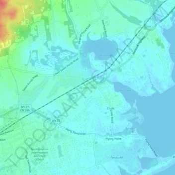
Name: Water Mill topographic map, elevation, terrain.
Location: Water Mill, Suffolk County, New York, 11976, United States (40.88593 -72.38203 40.92593 -72.34203)
Average elevation: 9 m
Minimum elevation: -5 m
Maximum elevation: 52 m
Other topographic maps
Click on a map to view its topography, its elevation and its terrain.
Deerfield
United States > New York > Suffolk County > Water Mill
Deerfield, Water Mill, Town of Southampton, Suffolk County, New York, 11976, United States
Average elevation: 27 m
Flying Point
United States > New York > Suffolk County > Water Mill
Flying Point, Water Mill, Town of Southampton, Suffolk County, New York, 11976, United States
Average elevation: 4 m
Cobb
United States > New York > Suffolk County > Water Mill
Cobb, Water Mill, Town of Southampton, Suffolk County, New York, 11976, United States
Average elevation: 5 m