
Marktoberdorf topographic map
Interactive map
Click on the map to display elevation.
About this map
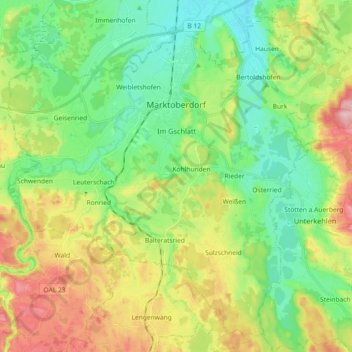
Name: Marktoberdorf topographic map, elevation, terrain.
Location: Marktoberdorf, Landkreis Ostallgäu, Bayern, 87616, Deutschland (47.69431 10.52981 47.80565 10.71268)
Average elevation: 770 m
Minimum elevation: 704 m
Maximum elevation: 888 m
Other topographic maps
Click on a map to view its topography, its elevation and its terrain.
Pfronten
Deutschland > Bayern > Landkreis Ostallgäu
Pfronten, Landkreis Ostallgäu, Bayern, 87459, Deutschland
Average elevation: 1,085 m
Füssen
Deutschland > Bayern > Landkreis Ostallgäu
Füssen, Landkreis Ostallgäu, Bayern, 87629, Deutschland
Average elevation: 852 m