
Checotah topographic map
Interactive map
Click on the map to display elevation.
About this map
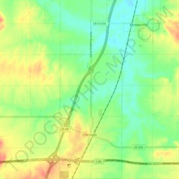
Name: Checotah topographic map, elevation, terrain.
Location: Checotah, McIntosh County, Oklahoma, 74426, United States (35.44943 -95.54899 35.53302 -95.50439)
Average elevation: 189 m
Minimum elevation: 168 m
Maximum elevation: 216 m
Checotah is located at an elevation of 652 feet (199 m) at the intersection of I-40 and U.S. Route 69. Nearby is Eufaula Lake, the largest-capacity lake wholly within the state of Oklahoma.
Other topographic maps
Click on a map to view its topography, its elevation and its terrain.
Honey Springs Battlefield
United States > Oklahoma > McIntosh County > Rentiesville
Honey Springs Battlefield, N4232 Road, Rentiesville, McIntosh County, Oklahoma, 74459, United States
Average elevation: 185 m