
Clinton topographic map
Interactive map
Click on the map to display elevation.
About this map
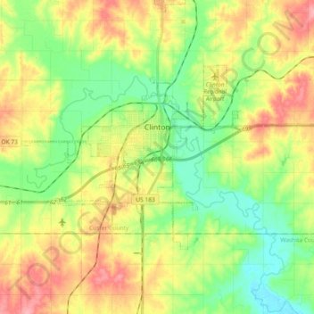
Name: Clinton topographic map, elevation, terrain.
Location: Clinton, Custer County, Oklahoma, 73601, United States (35.45769 -99.04621 35.54482 -98.86404)
Average elevation: 481 m
Minimum elevation: 439 m
Maximum elevation: 537 m
Other topographic maps
Click on a map to view its topography, its elevation and its terrain.
Moorewood
United States > Oklahoma > Custer County
Moorewood, Custer County, Oklahoma, United States
Average elevation: 557 m
Thomas
United States > Oklahoma > Custer County
Thomas, Custer County, Oklahoma, 73669, United States
Average elevation: 535 m
Arapaho
United States > Oklahoma > Custer County
Arapaho, Custer County, Oklahoma, 73620, United States
Average elevation: 494 m
Weatherford
United States > Oklahoma > Custer County > Weatherford > Weatherford
Weatherford, Custer County, Oklahoma, 73096, United States
Average elevation: 517 m
Weatherford
United States > Oklahoma > Custer County
Weatherford, Custer County, Oklahoma, 73096, United States
Average elevation: 514 m