
Olongapo topographic map
Interactive map
Click on the map to display elevation.
About this map
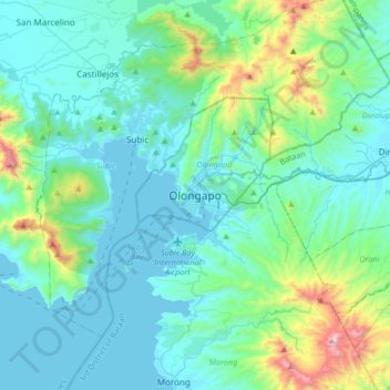
Name: Olongapo topographic map, elevation, terrain.
Location: Olongapo, Zambales, Central Luzon, 2200, Philippines (14.67147 120.12352 14.99147 120.44352)
Average elevation: 194 m
Minimum elevation: -3 m
Maximum elevation: 1,236 m
Other topographic maps
Click on a map to view its topography, its elevation and its terrain.
Nagsasa Cove
Philippines > Zambales > Olongapo
Nagsasa Cove, Nagsasa Trail, Olongapo, Zambales, Central Luzon, 2200, Philippines
Average elevation: 107 m