
Dnipropetrovsk Oblast topographic map
Interactive map
Click on the map to display elevation.
About this map
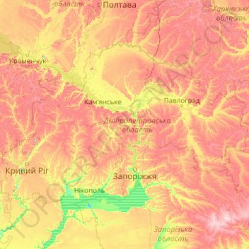
Name: Dnipropetrovsk Oblast topographic map, elevation, terrain.
Location: Dnipropetrovsk Oblast, Ukraine (47.45662 32.95955 49.19394 36.93683)
Average elevation: 110 m
Minimum elevation: 4 m
Maximum elevation: 313 m
Other topographic maps
Click on a map to view its topography, its elevation and its terrain.
Tankovoye
Ukraine > Republic of Crimea > Bakhchysarai Raion > Куйбышевское сельское поселение
Average elevation: 169 m
Dnipro
The source of the Dnieper is the sedge bogs (Akseninsky Mokh) of the Valdai Hills in central Russia, at an elevation of 220 m (720 ft). For 115 km (71 mi) of its length, it serves as the border between Belarus and Ukraine. Its estuary, or liman, used to be defended by the strong fortress of Ochakiv.
Average elevation: 110 m
Ai-Petri
Ukraine > Autonomous Republic of Crimea > Ялтинський район > Ливадийский поселковый совет
Average elevation: 819 m
Otradnoe
Ukraine > Autonomous Republic of Crimea > Ялтинський район
Vidradne is located on Crimea's southern shore at an elevation of 68 metres (223 ft). The settlement is located 9 km (5.6 mi) southeast from the town of Massandra, which it is administratively subordinate to. Its population was 582 at the 2001 Ukrainian census. Current population: 707 (2014 Census).
Average elevation: 103 m
мыс Тарханкут
Ukraine > Republic of Crimea > Chornomorske Raion > Оленевское сельское поселение
Average elevation: 2 m
Verecke Pass
The pass is located in the Carpathian Mountains just where the oblasts of Lviv and Transcarpathia meet, on the spine of the Northeastern Carpathians, between the Latorica (or Latorytsia) and Opir river valleys and at the river divide or watershed between the Latorytsia and the Stryi. It has an elevation of 841…
Average elevation: 749 m
Булганакское сопковое поле (Грязевые вулканы)
Ukraine > Autonomous Republic of Crimea > Lenine Raion > Войковское сельское поселение
Average elevation: 75 m
Kuibyshevo
Ukraine > Autonomous Republic of Crimea > Yalta city municipality > Ливадийский поселковый совет
Kuibysheve is located on Crimea's southern shore at an elevation of 232 metres (761 ft). The settlement is located 5 km (3.1 mi) from Yalta. Its population was 62 in the 2001 Ukrainian census. Current population: 67 (2014 Census).
Average elevation: 594 m
Basivka
The village covers an area of 2,39 km2 at an altitude of 305 metres (1,000 ft) above sea level. The population of village is just about 1042 persons and local government is administered by the Hodovytsko-Basivska village council.
Average elevation: 318 m
Basivka
The village covers an area of 2,39 km2 at an altitude of 305 metres (1,000 ft) above sea level. The population of village is just about 1042 persons and local government is administered by the Hodovytsko-Basivska village council.
Average elevation: 318 m
Dnipro
The source of the Dnieper is the sedge bogs (Akseninsky Mokh) of the Valdai Hills in central Russia, at an elevation of 220 m (720 ft). For 115 km (71 mi) of its length, it serves as the border between Belarus and Ukraine. Its estuary, or liman, used to be defended by the strong fortress of Ochakiv.
Average elevation: 110 m
Hoverla
In the 20th century, the mountain increasingly gained popularity as an extreme sports site. Some routes are classified as 1A in the winter period (from late autumn to May), according to the Soviet grading system. The most popular approach to the summit starts from the tour-basa Zarosliak on the mountain's…
Average elevation: 1,667 m
Baton
Ukraine > Autonomous Republic of Crimea > Feodosiya City Council > Ordzhonikidze
Average elevation: 8 m
Shcherbakovo
Ukraine > Republic of Crimea > Krasnohvardiiske Raion > Марьяновское сельское поселение
Average elevation: 39 m
Dmytrivka
Ukraine > Autonomous Republic of Crimea > Sovetskiy District > Дмитровское сельское поселение
Average elevation: 4 m