
Make a donation
Khasab Province topographic map
Click on the map to display elevation.
Make a donation
About this map
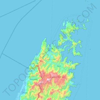
Name: Khasab Province topographic map, elevation, terrain.
Location: Khasab Province, Musandam Governorate, 811, Oman (25.83763 56.17379 26.50753 56.54856)
Average elevation: 141 m
Minimum elevation: -4 m
Maximum elevation: 2,059 m
Make a donation
Other topographic maps
Click on a map to view its topography, its elevation and its terrain.
Jebel Jais
Oman > Musandam Governorate > Bukha Province
Jebel Jais (Arabic: جبل جيس, romanized: Jabal Jays) is a mountain of the North-Western Hajar range in the Musandam Governorate of Oman and also in Ras Al Khaimah, United Arab Emirates. The summit has an elevation of 1,934 m (6,345 ft). The summit is located on the Omani side, but a high point west of…
Average elevation: 1,580 m
Make a donation
Jebel Jais
Oman > Musandam Governorate > Ra'lat al Yas
Jebel Jais (Arabic: جَبَل جَيْس, romanized: Jabal Jays) is a mountain of the North-Western Hajar range in the Musandam Governorate of Oman and also in Ras Al Khaimah, United Arab Emirates. The summit has an elevation of 1,934 m (6,345 ft). The summit is located on the Omani side, but a high point…
Average elevation: 1,580 m