
Make a donation
Sidama topographic map
Click on the map to display elevation.
Make a donation
Sidama
Sidama has a variety of climatic conditions. Warm conditions cover 54% of the area. Locally known as Gamoojje or Woinadega, this is a temperate zone ranging from an elevation of 1500 m to 2500 m above sea level. The mean annual rainfall of the area varies between 1200 mm and 1599 mm, with 15 °C to 19.9 °C average annual temperature. A hot climatic zone, Kolla, covers 30% of the total area. Its elevation ranges from 500 m to 1500 m above sea level. It has a mean annual rainfall of 400 mm to 799 mm, and the mean annual temperature ranges from 20 °C to 24.9 °C. Cool climatic conditions known as Aliicho or Dega exist in the mountainous highlands. This covers 16% of the total area with an elevation between 2500 m and 3500 m above sea level. This part gets the highest amount of rainfall, ranging from 1600 mm to 1999 mm. It has a mean annual temperature of 15 °C to 19.9 °C.
Make a donation
About this map
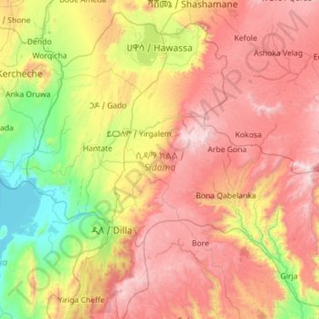
Name: Sidama topographic map, elevation, terrain.
Location: Sidama, Ethiopia (6.13875 38.00995 7.16567 39.13272)
Average elevation: 2,068 m
Minimum elevation: 1,174 m
Maximum elevation: 3,303 m
Make a donation
Other topographic maps
Click on a map to view its topography, its elevation and its terrain.
Addis Ababa
Ethiopia > Addis Ababa > Arada
Moreover, the city held strong social organizations pattern prior Italian invasion. According to Richard Pankhurst (1968), the city accelerated population growth due to factors of provisional governors and their troops, the 1892 famine, eventually the Battle of Adwa. Another include the 1907 land act,…
Average elevation: 2,517 m
Make a donation
Mekoni
Mekoni, also Mehoni (Ge'ez: መኾኒ or መሆኒ), is a town in the Tigray Region of Ethiopia. "Mekoni" (pronounced as 'Me-koni') is located at 657 km north of Addis Ababa along Ethiopian Highway 2 which runs to Mekelle (the capital city of Tigray region), Adigrat, Aksum, Shire and Humera with an altitude of 2479 m.
Average elevation: 1,806 m
Ogaden Desert
The Ogaden is a plateau, with an elevation above sea level that ranges from 1,500 metres (4,900 ft) in the northwest, falling to about 300 metres (980 ft) along the southern limits and the Wabi Shebelle valley. The areas with altitudes between 1,400 and 1,600 metres (4,600 and 5,200 ft) are characterised as…
Average elevation: 584 m
Addis Ababa
Ethiopia > Addis Ababa > Arada
Addis Ababa (/ˌædɪs ˈæbəbə/ AD-iss AB-ə-bə; Amharic: አዲስ አበባ [adˈdis ˈaβəβa] , lit. 'new flower'; Oromo: Finfinnee, lit. 'fountain of hot mineral water') is the capital city of Ethiopia. With an estimated population of 2,739,551 inhabitants as of the 2007 census, it is the largest…
Average elevation: 2,517 m
Make a donation
Demebecha
Dembecha is a town in northwestern Ethiopia 349 km north of Addis Ababa. Located in the Mirab Gojjam Zone of the Amhara Region, this town has a latitude and longitude of 10°33′N 37°29′E / 10.550°N 37.483°E / 10.550; 37.483 with an elevation of 2083 meters above sea level. It is one of three…
Average elevation: 2,125 m
Make a donation
Entoto
Ethiopia > Oromia Region > Sululta
The Ethiopian Heritage Trust, a non-profit, non-governmental organization, is working actively to change part of the mountain to its old state, a natural park. Entoto Natural Park is the northeastern rim of Addis Abeba, on the southeastern slopes of Mt. Entoto, covering an area of 1,300 hectares. It is…
Average elevation: 3,019 m
Make a donation
Hossana
Ethiopia > Central Ethiopia Regional State
Hosaena, Hossana or Hosaina is a town which level as a woreda in southern Ethiopia, and currently serve as the administrative center of Hadiya Zone and Central Ethiopia Regional State as well. Geographically located to the central south of Ethiopia, with a latitude and longitude of 7°33′N 37°51′E /…
Average elevation: 2,255 m
Make a donation
Naqamte
Nekemte, also spelled as Neqemte (Oromo: Naqamtee, Amharic: ነቀምት), is a market city and separate woreda in western Ethiopia. Located in the East Welega Zone of the Oromia Region, Nekemte has a latitude and longitude of 9°5′N 36°33′E / 9.083°N 36.550°E / 9.083; 36.550 and an elevation of 2,088 meters.
Average elevation: 1,909 m
Make a donation
Holeta Genet
Ethiopia > Oromia Region > Walmara
Holeta (Amharic: ሆለታ) (Oromo: Holataa) is a town in the special zone of Oromia Region, Ethiopia. It has a latitude and longitude of 9°3′N 38°30′E / 9.050°N 38.500°E / 9.050; 38.500 and an altitude of 2391 meters above sea level.
Average elevation: 2,391 m
Hawassa
Hawassa (Amharic: አዋሳ; ʾäwasa, also spelled Awassa or Awasa) known historically as Adare is a city in Ethiopia, on the shores of Lake Hawassa in the Great Rift Valley. It is 273 km (170 mi) south of Addis Ababa via Bishoftu, 130 km (81 mi) east of Sodo, and 75 km (47 mi) north of Dilla. The town serves…
Average elevation: 1,862 m
Gambela
Gambela (Amharic: ጋምቤላ), also spelled Gambella, is a city and separate woreda in Ethiopia and the capital of the Gambela Region. Located in Anyuak Zone, at the confluence of the Baro River and its tributary the Jajjabe, the city has a latitude and longitude of 8°15′N 34°35′E / 8.250°N…
Average elevation: 570 m
Make a donation
Make a donation
Abiy Addi
Abiy Addi has an elevation ranging from 1917 to 2275 meters above sea level. From the higher to the lower locations, the following geological formations are present: Ashangi Basalts, Amba Aradam Formation, Adigrat Sandstone, and Edaga Arbi Glacials.
Average elevation: 1,957 m
Hagere Selam
Hagere Selam (Tigrinya: ሃገረ ሰላም) is a town in northern Ethiopia. Located on the Mekelle-Abiy Addi regional road, it is located at an elevation of 2650 metres above sea level. The town is the administrative center of the Dogu'a Tembien woreda. The weekly market is on Saturdays.
Average elevation: 2,446 m
Make a donation
Chiro
Chiro (also called Asebe Teferi or Asba Littoria; Afaan Oromo: Ciroo) is a town and Aanaa in eastern Ethiopia. Located in the West Hararghe Zone in Oromia Regional State, Ethiopia Ahmar Mountains, it has a latitude and longitude of 9°05′N 40°52′E / 9.083°N 40.867°E / 9.083; 40.867 and an…
Average elevation: 1,870 m
Make a donation
Turmi
Ethiopia > South Ethiopia Regional State
Turmi is a market town in south-western Ethiopia. Located in the Debub Omo Zone of the South Ethiopia Regional State, the town has a latitude and longitude of 4°58′N 36°29′E / 4.967°N 36.483°E / 4.967; 36.483 with an elevation of 925 metres above sea level.
Average elevation: 921 m
Hawassa
Hawassa (Amharic: አዋሳ; ʾäwasa, also spelled Awassa or Awasa) known historically as Adare is a city in Ethiopia, on the shores of Lake Awassa in the Great Rift Valley. It is 273 km (170 mi) south of Addis Ababa via Bishoftu, 130 km (81 mi) east of Sodo, and 75 km (47 mi) north of Dilla. The town serves…
Average elevation: 1,862 m
Make a donation
Addis Ababa
Ethiopia > Addis Ababa > Arada
Moreover, the city held strong social organization patterns prior to the Italian invasion. According to Richard Pankhurst (1968), the city's accelerated population growth was due to factors of provisional governors and their troops, the 1892 famine, and eventually the Battle of Adwa. Another includes the 1907…
Average elevation: 2,517 m
Sendafa
Sendafa (Oromo: Sandafaa) is a town and separate woreda in Oromia Region, Ethiopia. Its name is taken from the Oromo name for a kind of thick, jointed grass or reed which grows in swampy areas. Located in the Oromia Special Zone Surrounding Finfinne of the Oromia Region, Sendafa has a latitude and longitude of…
Average elevation: 2,594 m
Make a donation
Dilla
Ethiopia > South Ethiopia Regional State
Dilla (Amharic: ዲላ) is a market town and separate woreda in southern Ethiopia. The administrative center of the Gedeo Zone in the former Southern Nations, Nationalities, and Peoples Region (SNNPR) now it is South Ethiopia Regional State (SER), it is located on the main road from Addis Ababa to Nairobi. The…
Average elevation: 1,886 m
Make a donation
Nech Sar National Park
Ethiopia > South Ethiopia Regional State > Arba Minch
Average elevation: 1,215 m
Make a donation
Waliso
Waliso (Oromo: Walisoo) is a town in Southwest Shewa Zone of the Oromia Region in Ethiopia, 114 km southwest of Addis Ababa, it has a latitude and longitude of 8°32′N 37°58′E / 8.533°N 37.967°E / 8.533; 37.967 with an elevation of 2063 meters above sea level. Waliso is the administrative center of this Zone.
Average elevation: 2,044 m
Make a donation
Make a donation
Asosa
Ethiopia > Benishangul-Gumuz Region
Asosa or Assosa is the capital of Benishangul-Gumuz Region, Ethiopia. Located in the Asosa Zone, this town has a latitude and longitude of 10°04′N 34°31′E / 10.067°N 34.517°E / 10.067; 34.517, with an elevation of 1,570 meters.
Average elevation: 1,301 m
Sagure
Sagure is a town in south-eastern Ethiopia. Located in the Arsi Zone of the Oromia, this town has a latitude and longitude of 07°45′N 39°09′E / 7.750°N 39.150°E / 7.750; 39.150 with an elevation of 2568 meters above sea level. It is the administrative center of Digeluna Tijo, woreda.
Average elevation: 2,521 m
Make a donation
Bekoji
Bekoji (Oromo: Boqojjii, Amharic: በቆጂ) is a town in central Ethiopia. Located in the Arsi Zone of the Oromia Region, it has a latitude and longitude of 7°35′N 39°10′E / 7.583°N 39.167°E / 7.583; 39.167 with an elevation of 2810 m. It is the administrative centre of Limuna Bilbilo woreda.
Average elevation: 2,792 m
Make a donation
Mieso
Mieso (Oromo: Mi'eesso) is a town in eastern Ethiopia. Located in the WEST OROMIA of the OROMIA Region, it has a latitude and longitude of 9°14′N 40°45′E / 9.233°N 40.750°E / 9.233; 40.750 with an elevation of 1394 meters above sea level.
Average elevation: 1,369 m
Naqamte
Nekemte, also spelled as Neqemte (Oromo: Naqamtee, Amharic: ነቀምት), is a market city and separate woreda in western Ethiopia. Located in the East Welega Zone of the Oromia Region, Nekemte has a latitude and longitude of 9°5′N 36°33′E / 9.083°N 36.550°E / 9.083; 36.550 and an elevation of 2,088 meters.
Average elevation: 1,909 m
Injibara
Injibara (Amharic: እንጅባራ) is a town in Ethiopia. It is the administrative center of the Agew Awi Zone in the Amhara Region. Injibara is located at 10°57′N 36°56′E / 10.950°N 36.933°E / 10.950; 36.933, in Banja Shekudad woreda at an elevation of 2,560 meters (8,400 ft) above sea level.
Average elevation: 2,575 m
Make a donation
Make a donation
Bonga
Ethiopia > South West Ethiopia Peoples
Bonga is a town, woreda and one of the multicapital of the South West Ethiopia Peoples' Region in Ethiopia. Located in the Keffa Zone upon a hill in the upper Barta valley, it has a latitude and longitude of 7°16′N 36°14′E / 7.267°N 36.233°E / 7.267; 36.233 with an elevation of 1,714 meters…
Average elevation: 1,769 m
Make a donation
Make a donation
Mota
Mota (Amharic: ሞጣ) is a town in northwest Ethiopia. It is located in the Misraq Gojjam Zone of the Amhara Region on the secondary road that links Dejen with Bahir Dar overlooking the Abay River. The town has a latitude and longitude of 11°5′N 37°52′E / 11.083°N 37.867°E / 11.083; 37.867…
Average elevation: 2,383 m
Make a donation
Entoto
Ethiopia > Oromia Region > Sululta
The Ethiopian Heritage Trust, a non-profit, non-governmental organization, is working actively to change part of the mountain to its old state, a natural park. Entoto Natural Park is the northeastern rim of Addis Abeba, on the southeastern slopes of Mt. Entoto, covering an area of 1,300 hectares. It is…
Average elevation: 3,019 m
Dilla
Ethiopia > South Ethiopia Regional State
Dilla (Amharic: ዲላ) is a market town and separate woreda in southern Ethiopia. The administrative center of the Gedeo Zone in the former Southern Nations, Nationalities, and Peoples Region (SNNPR) now it is South Ethiopia Regional State (SER), it is located on the main road from Addis Ababa to Nairobi. The…
Average elevation: 1,886 m
Make a donation
Lake Hawassa
Lake Hawassa or Awasa, is an endorheic basin in Sidama Region of Ethiopia, located in the Main Ethiopian Rift south of Addis Ababa, the capital city of the country. According to the Statistical Abstract of Ethiopia for 1967/68, the lake is 16 km long and 9 km wide, with a surface area of 129 square kilometers.…
Average elevation: 1,705 m
Make a donation