
Le Bas topographic map
Interactive map
Click on the map to display elevation.
About this map
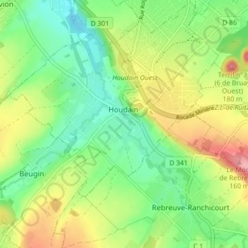
Name: Le Bas topographic map, elevation, terrain.
Average elevation: 87 m
Minimum elevation: 37 m
Maximum elevation: 165 m
Other topographic maps
Click on a map to view its topography, its elevation and its terrain.
Le Haut
France > Hauts-de-France > Pas-de-Calais > Houdain
Le Haut, Houdain, Béthune, Pas-de-Calais, Hauts-de-France, France métropolitaine, 62150, France
Average elevation: 81 m