
Thank you for supporting this site ❤️
Make a donation
Make a donation
Lac Mandeville topographic map
Click on the map to display elevation.
Thank you for supporting this site ❤️
Make a donation
Make a donation
About this map
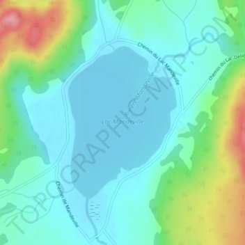
Name: Lac Mandeville topographic map, elevation, terrain.
Average elevation: 173 m
Minimum elevation: 143 m
Maximum elevation: 267 m
Thank you for supporting this site ❤️
Make a donation
Make a donation
Other topographic maps
Click on a map to view its topography, its elevation and its terrain.
Rivière Mandeville
Canada > Québec > D'Autray > Mandeville > Saint-Charles-de-Mandeville
Average elevation: 229 m