
Mariyapuram topographic map
Interactive map
Click on the map to display elevation.
About this map
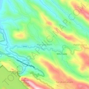
Name: Mariyapuram topographic map, elevation, terrain.
Location: Mariyapuram, Idukki, Idukki District, Kerala, 685602, India (9.83685 76.96840 9.87685 77.00840)
Average elevation: 687 m
Minimum elevation: 526 m
Maximum elevation: 957 m
Other topographic maps
Click on a map to view its topography, its elevation and its terrain.
Calvary Mount
Calvary Mount, Idukki, Idukki District, Kerala, 685512, India
Average elevation: 944 m
Thoppipala
India > Kerala > Idukki > Labbakada
Thoppipala, Labbakada, Idukki, Idukki District, Kerala, 685511, India
Average elevation: 842 m
Idduki Resorvoir View
India > Kerala > Idukki > Vellayamkudi
Idduki Resorvoir View, Adimali - Kumily Highway, Idukki Kavala, Vellayamkudi, Idukki, Idukki District, Kerala, 685512, India
Average elevation: 969 m