
Plaik topographic map
Interactive map
Click on the map to display elevation.
About this map
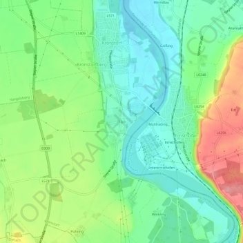
Name: Plaik topographic map, elevation, terrain.
Location: Plaik, Kronstorf, Bezirk Linz-Land, 4484, Österreich (48.10929 14.44686 48.14929 14.48686)
Average elevation: 296 m
Minimum elevation: 257 m
Maximum elevation: 369 m
Other topographic maps
Click on a map to view its topography, its elevation and its terrain.
Kronstorf
Kronstorf, Bezirk Linz-Land, 4484, Österreich
Average elevation: 300 m
Teufelsgraben
Österreich > Bezirk Linz-Land > Kronstorf
Teufelsgraben, Kronstorf, Bezirk Linz-Land, 4484, Österreich
Average elevation: 338 m
Edramsberg
Edramsberg, Wilhering, Bezirk Linz-Land, 4073, Österreich
Average elevation: 309 m
Gemering
Österreich > Bezirk Linz-Land > Sankt Florian > Ölkam
Gemering, Ölkam, Sankt Florian, Bezirk Linz-Land, 4490, Österreich
Average elevation: 289 m
Wagram
Wagram, Pasching, Bezirk Linz-Land, 4061, Österreich
Average elevation: 282 m
Reith
Österreich > Bezirk Linz-Land > Leonding
Reith, Leonding, Bezirk Linz-Land, 4060, Österreich
Average elevation: 289 m
Kematen an der Krems
Kematen an der Krems, Bezirk Linz-Land, 4531, Österreich
Average elevation: 353 m
Neuhofen an der Krems
Neuhofen an der Krems, Bezirk Linz-Land, 4501, Österreich
Average elevation: 335 m