
Free State topographic map
Interactive map
Click on the map to display elevation.
About this map
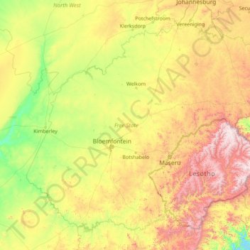
Name: Free State topographic map, elevation, terrain.
Location: Free State, RSA (-30.69408 24.34662 -26.66874 29.78513)
Average elevation: 1,499 m
Minimum elevation: 980 m
Maximum elevation: 3,379 m
Other topographic maps
Click on a map to view its topography, its elevation and its terrain.
Matjhabeng Local Municipality
RSA > Free State > Matjhabeng Local Municipality
Matjhabeng Local Municipality, Lejweleputswa District Municipality, Free State, RSA
Average elevation: 1,376 m
Mangaung Ward 39
RSA > Free State > Thaba Nchu
Mangaung Ward 39, Thaba Nchu, Mangaung Metropolitan Municipality, Free State, RSA
Average elevation: 1,517 m
Xhariep District Municipality
Xhariep District Municipality, Free State, RSA
Average elevation: 1,371 m
Matjhabeng Ward 32
RSA > Free State > Matjhabeng Local Municipality
Matjhabeng Ward 32, Matjhabeng Local Municipality, Lejweleputswa District Municipality, Free State, RSA
Average elevation: 1,358 m