
Thank you for supporting this site ❤️
Make a donation
Make a donation
Sarapul topographic map
Click on the map to display elevation.
Thank you for supporting this site ❤️
Make a donation
Make a donation
About this map
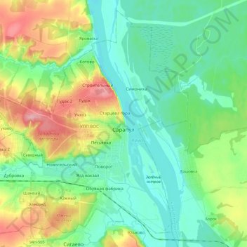
Name: Sarapul topographic map, elevation, terrain.
Location: Sarapul, Udmurtia, Volga Federal District, Russia (56.42498 53.65909 56.53528 53.87609)
Average elevation: 95 m
Minimum elevation: 58 m
Maximum elevation: 184 m
Thank you for supporting this site ❤️
Make a donation
Make a donation
Other topographic maps
Click on a map to view its topography, its elevation and its terrain.