Geolocate

Pinerolo topographic map

Click on the map to display elevation.

About this map

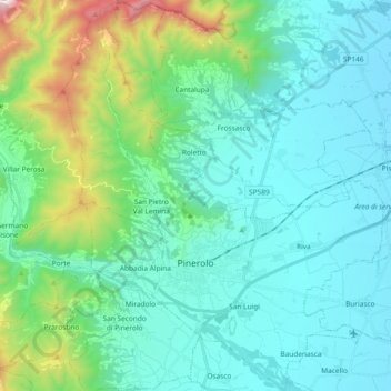
Name: Pinerolo topographic map, elevation, terrain.

Location: Pinerolo, Turin, Piedmont, 10064, Italy (44.84415 7.27962 44.97584 7.42167)

Average elevation: 528 m

Minimum elevation: 278 m

Maximum elevation: 1,638 m

Other topographic maps

Click on a map to view its topography, its elevation and its terrain.

Magnoletto

Italy > Piedmont > Turin > Condove

Average elevation: 699 m

Pratobotrile

Italy > Piedmont > Turin > Condove

Average elevation: 1,117 m

Turin

Italy > Piedmont > Turin

Average elevation: 295 m

Turin

Italy > Piedmont > Turin

Average elevation: 295 m

Rivetto

Italy > Piedmont > Turin > San Giorio di Susa

Average elevation: 583 m

Famolasco

Italy > Piedmont > Turin

Average elevation: 508 m

Morelli

Italy > Piedmont > Turin > Gravere

Average elevation: 785 m

La Cialma

Italy > Piedmont > Turin > Locana

Average elevation: 1,705 m

Tornetti

Italy > Piedmont > Turin > Viù

Average elevation: 1,333 m

Baio Dora

Italy > Piedmont > Turin

Average elevation: 494 m

Turin

Italy > Piedmont > Turin

Average elevation: 295 m

Belvedere

Italy > Piedmont > Turin > Borgiallo

Average elevation: 733 m