
Coal Mountain topographic map
Interactive map
Click on the map to display elevation.
About this map
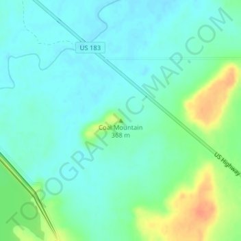
Name: Coal Mountain topographic map, elevation, terrain.
Location: Coal Mountain, Stephens County, Texas, United States (32.82840 -98.94345 32.82850 -98.94335)
Average elevation: 354 m
Minimum elevation: 342 m
Maximum elevation: 383 m
Other topographic maps
Click on a map to view its topography, its elevation and its terrain.
Ivan
United States > Texas > Stephens County
Ivan, Stephens County, Texas, United States
Average elevation: 355 m
Breckenridge
United States > Texas > Stephens County > Breckenridge > Breckenridge
Breckenridge, Stephens County, Texas, 76424, United States
Average elevation: 379 m
Breckenridge
United States > Texas > Stephens County
Breckenridge, Stephens County, Texas, 76424, United States
Average elevation: 377 m