
Natales topographic map
Interactive map
Click on the map to display elevation.
About this map
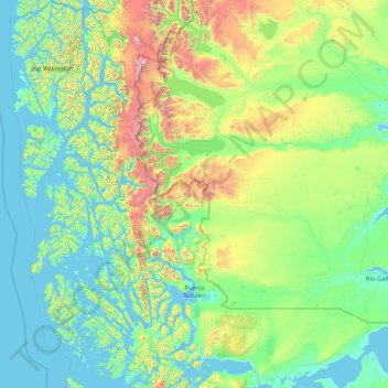
Name: Natales topographic map, elevation, terrain.
Average elevation: 279 m
Minimum elevation: -3 m
Maximum elevation: 3,546 m
Other topographic maps
Click on a map to view its topography, its elevation and its terrain.
Southern Patagonian Ice Field
Chile > XII Region of Magallanes and Chilean Antarctica > Natales
Average elevation: 656 m
Duke of York Island
Chile > XII Region of Magallanes and Chilean Antarctica > Natales
Average elevation: 65 m